Port-au-Prince Transit (PAPT)

A transformative vision for urban mobility, connecting communities, fostering economic growth, and championing sustainable development in Haiti’s capital city.

PAPT Detailed Overview

The Port-au-Prince Transit (PAPT) system is conceived as an integrated network of elevated, accessible, and seamlessly connected transit lines. Inspired by global exemplars like the Hong Kong MTR, PAPT is designed to address the unique challenges of Port-au-Prince’s geography, infrastructure, and rapid urbanization.

By reducing dependence on personal vehicles and informal transportation options, PAPT aims to ease congestion, lower emissions, and promote a more sustainable urban environment. Beyond transportation, PAPT supports the broader vision of social and economic vitality—helping people move effortlessly between work, school, and home, while attracting businesses and investment to the city’s core.

Route Planning & Stations

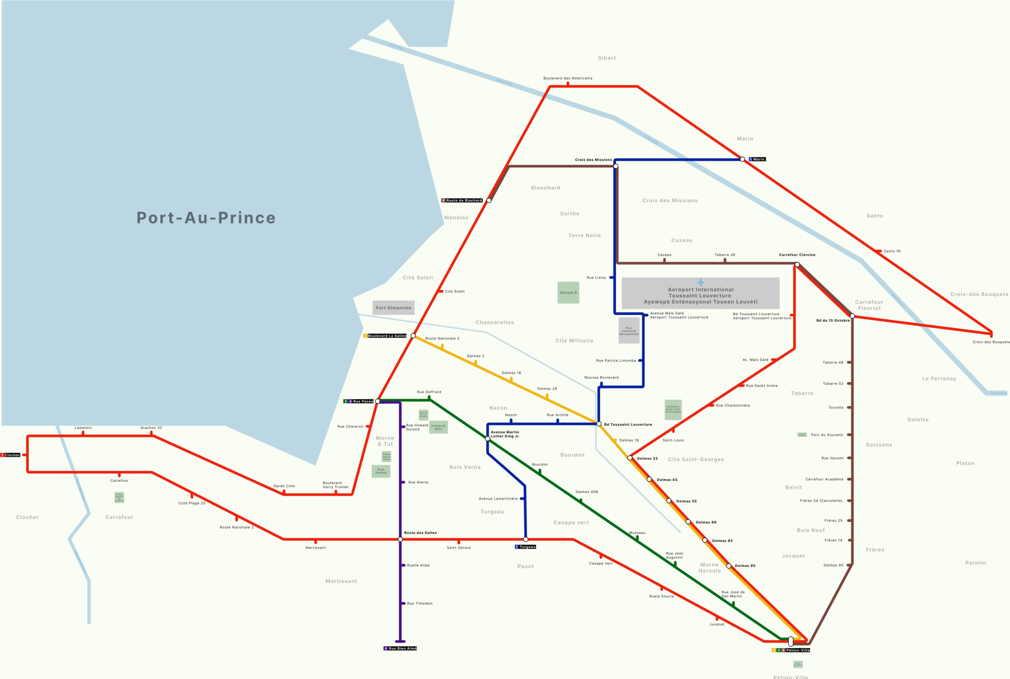
PAPT’s proposed network features multiple lines radiating through key districts. The circular “Port-au-Prince Loop” anchors the system, connecting Carrefour, the airport, Petion-Ville, and other vital neighborhoods. Additional lines like the Carrefour Line and Delmas Line extend coverage, ensuring that major employment centers, markets, and community hubs are within easy reach.

Stations are envisioned as vibrant, safe, and accessible spaces. Design principles emphasize clear signage, universal access features (elevators, ramps), ample lighting, security measures, and well-integrated transfer stations that minimize travel times.
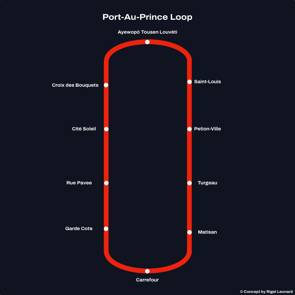
PAPT Loop Concept

Figure: A conceptual diagram of the Port-au-Prince Loop, highlighting interconnected lines and key transfer points.
Infrastructure & Sustainable Energy

Building PAPT isn’t just about tracks and trains—it’s about crafting a holistic infrastructure strategy. Powering the network with renewable energy, particularly solar, aligns with Haiti’s abundant sunlight and environmental goals. Integrating smart grids, energy storage, and efficient power distribution reduces operational costs and ensures reliable service.

Elevated lines are chosen to navigate the city’s challenging terrain and seismic considerations. They also allow for creative urban design underneath the tracks—potentially transforming formerly congested streets into pedestrian-friendly spaces.

Route Planning & Stations

PAPT’s proposed network features multiple lines radiating through key districts. The circular “Port-au-Prince Loop” anchors the system, connecting Carrefour, the airport, Petion-Ville, and other vital neighborhoods. Additional lines like the Carrefour Line and Delmas Line extend coverage, ensuring that major employment centers, markets, and community hubs are within easy reach.

Stations are envisioned as vibrant, safe, and accessible spaces. Design principles emphasize clear signage, universal access features (elevators, ramps), ample lighting, security measures, and well-integrated transfer stations that minimize travel times.

PAPT Route Map

Figure: A conceptual PAPT route map, illustrating various lines, stations. View Full Map on Figma

Challenges & Future Vision

Implementing PAPT involves navigating financial, engineering, and political complexities. Securing funding, forging public-private partnerships, and coordinating with local communities and stakeholders is essential. Yet, these challenges are stepping stones towards a more sustainable and prosperous urban future.

As PAPT evolves, its scalability allows for incremental expansion—adding new lines, upgrading stations, and incorporating emerging technologies. This adaptability ensures that Port-au-Prince’s transit infrastructure can continuously improve, meeting the changing needs of the city’s growing population.